
Potsdam-Mittelmark: Difference between revisions
No edit summary |
m Bot: Migrating 24 interwiki links, now provided by Wikidata on d:q6142 (Report Errors) |
||
| Line 108: | Line 108: | ||
[[ko:포츠담미텔마르크 군]] |
[[ko:포츠담미텔마르크 군]] |
||
[[af:Potsdam-Mittelmark]] |
|||
[[da:Landkreis Potsdam-Mittelmark]] |
|||
[[de:Landkreis Potsdam-Mittelmark]] |
|||
[[es:Distrito de Potsdam-Mittelmark]] |
|||
[[eo:Distrikto Potsdam-Mittelmark]] |
|||
[[fr:Arrondissement de Potsdam-Mittelmark]] |
|||
[[id:Potsdam-Mittelmark]] |
|||
[[it:Circondario di Potsdam-Mittelmark]] |
|||
[[kk:Потсдам-Миттельмарк (аудан)]] |
|||
[[ms:Potsdam-Mittelmark]] |
|||
[[nl:Landkreis Potsdam-Mittelmark]] |
|||
[[no:Potsdam-Mittelmark]] |
|||
[[uz:Potsdam-Mittelmark (tuman)]] |
|||
[[pnb:پوٹسڈیم متلمارک]] |
|||
[[pl:Powiat Potsdam-Mittelmark]] |
|||
[[pt:Potsdam-Mittelmark]] |
|||
[[ro:Potsdam-Mittelmark (district)]] |
|||
[[ru:Потсдам-Миттельмарк (район)]] |
|||
[[simple:Potsdam-Mittelmark]] |
|||
[[sr:Округ Потсдам-Мителмарк]] |
|||
[[sv:Landkreis Potsdam-Mittelmark]] |
|||
[[vi:Potsdam-Mittelmark (huyện)]] |
|||
[[war:Potsdam-Mittelmark]] |
|||
[[zh:波茨坦-米特尔马克县]] |
|||
Revision as of 21:22, 21 February 2013
Potsdam-Mittelmark | |
|---|---|
 | |
| Country | Germany |
| State | Brandenburg |
| Capital | Belzig |
| Area | |
| • Total | 2,575.4 km2 (994.4 sq mi) |
| Population (31 December 2022)[1] | |
| • Total | 222,570 |
| • Density | 86/km2 (220/sq mi) |
| Time zone | UTC+01:00 (CET) |
| • Summer (DST) | UTC+02:00 (CEST) |
| Vehicle registration | PM |
| Website | potsdam-mittelmark.de |
Potsdam-Mittelmark is a Kreis (district) in the western part of Brandenburg, Germany. Neighboring are (from the north clockwise) the district Havelland, the district free cities Brandenburg and Potsdam, the Bundesland Berlin, the district Teltow-Fläming, and the districts Wittenberg, Anhalt-Bitterfeld and Jerichower Land in Saxony-Anhalt.
Geography
The district includes the southern banks of the Havel river and the northern parts of the Fläming (a wooded hill chain). There are three nature parks in the district: High Fläming Nature Park, Nuthe-Nieplitz Nature Park, Westhavelland Nature Park.
History
The district was created in 1993 by merging the previous districts Belzig, Brandenburg-Land and Potsdam-Land.
Demography
-
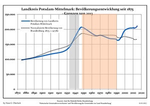 Development of Population since 1875 within the Actual Boundaries (Blue Line: Population; Dotted Line: Comparison to Population Development of Brandenburg state; Grey Background: Time of Nazi rule; Red Background: Time of Communist rule)
 -
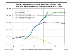 Recent Population Development (Blue Line) and Forecasts


Coat of arms

|
The coat of arms is divided into four fields. The left top one shows a red eagle as the symbol of Brandenburg. The three oak-leaves in the top right both symbolize the prevalent oak forests, but also the three previous districts which were merged to form the current one. In the bottom right are two bishopric keys, which stand for the diocese of Brandenburg. The black-and-golden bars in the bottomleft are the symbol of Saxony, and symbolize that the area around Belzig, Brück, Wiesenburg and Niemegk belonged to Saxony until 1815. |
Towns and municipalities

| Amt-free towns | Ämter | |
|---|---|---|
|
|
1. Beetzsee 2. Brück 3. Niemegk |
4. Wusterwitz 5. Ziesar |
| 1seat of the Amt; 2town | ||
References
- ^ "Bevölkerungsentwicklung und Bevölkerungsstandim Land Brandenburg Dezember 2022" (PDF). Amt für Statistik Berlin-Brandenburg (in German). June 2023.
External links
![]() Media related to Potsdam-Mittelmark at Wikimedia Commons
Media related to Potsdam-Mittelmark at Wikimedia Commons
| Urban districts | |
|---|---|
| Rural districts | |